


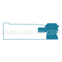
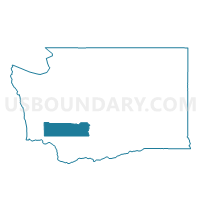
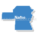
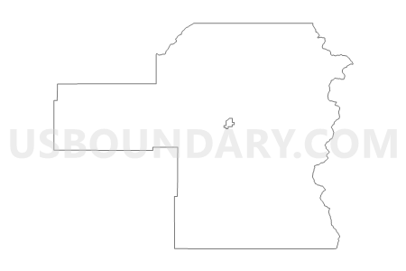
Big Bottom Voting District, Lewis County, Washington
About
Outline

Summary
| Unique Area Identifier | 687493 |
| Name | Big Bottom Voting District |
| County | Lewis County |
| State | Washington |
| Area (square miles) | 634.57 |
| Land Area (square miles) | 630.97 |
| Water Area (square miles) | 3.60 |
| % of Land Area | 99.43 |
| % of Water Area | 0.57 |
| Latitude of the Internal Point | 46.59287350 |
| Longtitude of the Internal Point | -121.67851550 |
Maps

Graphs
Select a template below for downloading or customizing gragh for Big Bottom Voting District, Lewis County, Washington


Neighbors
Neighoring Voting District (by Name) Neighboring Voting District on the Map
- Voting District 02-058, Pierce County, WA
- Chenowith North Voting District, Skamania County, WA
- Mineral Voting District, Lewis County, WA
- N Tampico Voting District, Yakima County, WA
- Nile Voting District, Yakima County, WA
- Packwood Voting District, Lewis County, WA
- Randle East Voting District, Lewis County, WA
- Randle West Voting District, Lewis County, WA
- Rimrock Voting District, Yakima County, WA
- Tampico Voting District, Yakima County, WA
- Verndale Voting District, Lewis County, WA
- White Swan Voting District, Yakima County, WA
- Wind Mountain North Voting District, Skamania County, WA
Top 10 Neighboring County Subdivision (by Population) Neighboring County Subdivision on the Map
- Northwest Yakima CCD, Yakima County, WA (8,252)
- Mineral CCD, Lewis County, WA (4,175)
- South Yakima CCD, Yakima County, WA (3,682)
- Mount Rainier CCD, Pierce County, WA (3,406)
- Morton CCD, Lewis County, WA (2,931)
- Big Bottom CCD, Lewis County, WA (2,911)
- North Skamania CCD, Skamania County, WA (98)
Top 10 Neighboring Place (by Population) Neighboring Place on the Map
Top 10 Neighboring Unified School District (by Population) Neighboring Unified School District on the Map
- West Valley School District, WA (28,648)
- Eatonville School District, WA (12,084)
- Naches Valley School District, WA (8,078)
- Stevenson-Carson School District, WA (6,199)
- Mount Adams School District, WA (4,380)
- White Pass School District, WA (4,080)
- Morton School District, WA (2,742)
Top 10 Neighboring State Legislative District Lower Chamber (by Population) Neighboring State Legislative District Lower Chamber on the Map
- State House District 2, WA (163,707)
- State House District 20, WA (141,029)
- State House District 15, WA (132,788)
- State House District 14, WA (130,478)
Top 10 Neighboring State Legislative District Upper Chamber (by Population) Neighboring State Legislative District Upper Chamber on the Map
- State Senate District 2, WA (163,707)
- State Senate District 20, WA (141,029)
- State Senate District 15, WA (132,788)
- State Senate District 14, WA (130,478)
Top 10 Neighboring 111th Congressional District (by Population) Neighboring 111th Congressional District on the Map
- Congressional District 8, WA (810,754)
- Congressional District 3, WA (779,348)
- Congressional District 4, WA (774,409)
Top 10 Neighboring Census Tract (by Population) Neighboring Census Tract on the Map
- Census Tract 30.01, Yakima County, WA (4,584)
- Census Tract 9718, Lewis County, WA (4,175)
- Census Tract 9400.03, Yakima County, WA (3,682)
- Census Tract 701, Pierce County, WA (3,406)
- Census Tract 9719, Lewis County, WA (2,931)
- Census Tract 9720, Lewis County, WA (2,911)
- Census Tract 9501, Skamania County, WA (98)
Top 10 Neighboring 5-Digit ZIP Code Tabulation Area (by Population) Neighboring 5-Digit ZIP Code Tabulation Area on the Map
- 98903, WA (14,517)
- 98937, WA (4,112)
- 98377, WA (1,922)
- 98361, WA (1,158)
- 98336, WA (970)
- 98304, WA (759)
- 98355, WA (628)